Oscar M. Baez-Villanueva, Hydro-Climate Extremes Lab (H-CEL), Ghent University, Ghent, Belgium; Mauricio Zambrano-Bigiarini, associate researcher CR2; Diego G. Miralles, Hydro-Climate Extremes Lab (H-CEL), Ghent University, Ghent, Belgium; Hylke E. Beck, Climate and Livability Initiative, Physical Sciences and Engineering, King Abdullah University of Science and Technology, Thuwal, Saudi Arabia; Jonatan F. Siegmund, Ernst & Young GmbH, Wirtschaftsprüfungsgesellschaft, Stuttgart, Germany; Camila Alvarez-Garreton, CR2 researcher; Koen Verbist, UNESCO International Hydrological Programme, Paris, France; René Garreaud, CR2 deputy director; Juan Pablo Boisier, CR2 researcher; Mauricio Galleguillos, CR2 associate researcher.
- Although there are many drought indices, not all of them are equally useful for monitoring the water flowing in the country’s rivers.
- A recent study recommends using drought indices considering precipitation and evaporation variables.
- The hydrological regime of each basin (pluvial, nival, or mixed) is of the utmost importance when deciding which index to use to monitor drought.
Since 2010, central Chile has experienced a mega-drought due to both natural variability and anthropogenic climate change (CR2 2015; Garreaud, 2017). This condition of lower precipitation combined with higher water use has generated high or extreme water stress in most basins between the Elqui and Rapel rivers, decreasing water availability (Alvarez-Garreton et al., 2023).
Consequently, tools are necessary to monitor the drought affecting Chilean rivers, and one of these is the use of so-called “drought indices.” However, there is currently a wide variety of these indices, and no consensus has been reached on which are most suitable for monitoring water availability in the country’s main basins.
A scientific article published in Hydrology and Earth System Sciences (Baez-Villanueva et al., 2023) attempted to answer this question and identify a drought index suitable for monitoring the amount of water flowing in the rivers of Chile’s main basins. This would allow the development of proactive mitigation and management strategies to reduce the impact of drought on the population and ecosystems, considering the relatively limited existence of river monitoring stations.
Methodology
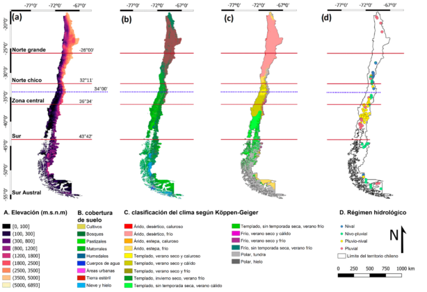
The study selected 100 basins in the country with streamflow data and minimal human intervention, e.g., no dams, less than 10% of flows for consumption, low extraction for irrigation, and less than 20% of the area covered by forest plantations. The selected basins varied in size, elevation, land cover type, aridity, and annual precipitation regime (Figure 1).

Regarding the hydrological regime, 16 basins were selected where the main water source is snow (nival), 25 basins mainly fed by snow with a minor rain contribution (nivo-pluvial), 40 basins whose main water source is rain with a minor snow contribution (pluvio-nival), and 19 basins mainly fed by rain (pluvial).
In each basin, the Standardized Streamflow Index (SSI) was used to represent the drought affecting the rivers. Additionally, four other drought indices based on more widely available data were used: the Standardized Precipitation Index (SPI), Standardized Precipitation Evapotranspiration Index (SPEI), Empirical Standardized Soil Moisture Index (ESSMI), and Standardized Snow Water Equivalent Index (SWEI). These four indices were compared with the SSI to identify which one best approximated the streamflow index values, aiming to identify the index or indices to use in basins without streamflow data. All estimates were developed for 1979-2020.
Results
One of the main results is that there is no single drought index whose use can be recommended to adequately characterize and monitor streamflows in Chilean basins due to the spatial and temporal variability of precipitation, snow, and soil moisture in the territory.
In this sense, the hydrological regime of the basins influences the type of drought index that should be used to adequately monitor streamflows and the most appropriate temporal accumulation.
Recommendations
- To characterize streamflows in pluvial basins that rapidly accumulate water, the SPI and SPEI with a 3-month temporal accumulation (SPI-3 and SPEI-3) are recommended.
- For nival basins, the SPI over 12 to 24 months (SPI-12 and SPI-24) and the SPEI over 18 months (SPEI-18) should be used, as their hydrological regime is based on snow, a slow water accumulation process.
- For nivo-pluvial basins, the suggested temporal accumulation varies between 3 and 12 months (SPI-6, SPI-12, SPEI-3, and SPEI-9), while for pluvio-nival basins, it ranges from 3 to 6 months (SPI-3, SPI-6, and SPEI-3).
- To evaluate the influence of snow on streamflow drought, this study considered the Standardized Snow Water Equivalent Index (SWEI). However, for future studies, we recommend using the Standardized Melt and Rainfall Index (SMRI; Staudinger et al., 2014). This index requires implementing and calibrating a model capable of representing snow processes in the target basins and has been widely used as a complement to the SPI because it considers both precipitation and snowmelt water deficits.
References
Alvarez-Garreton, C., Boisier, J.P., Blanco, G., Billi, M., Nicolas-Artero, C., Maillet, A., Aldunce, P., Urrutia-Jalabert, R., Zambrano-Bigiarini, M., Guevara, G., Galleguillos, M., Muñoz, A., Christie, D., Marinao, R., & Garreaud, R. (2023). Water Security in Chile: Characterization and Future Perspectives. Climate and Resilience Sciences Center CR2 (ANID/FONDAP/1522A0001), 72 pp. Available at www.cr2.cl/seguridadhidrica
Baez-Villanueva, O.M., Zambrano-Bigiarini, M., Miralles, D.G., Beck, H.E., Siegmund, J.F., Alvarez-Garreton, C., Verbist, K., Garreaud, R., Boisier, J.P., Galleguillos, M. (2024). On the timescale of drought indices for monitoring streamflow drought considering catchment hydrological regimes, Hydrology and Earth System Sciences 28, 1415–1439, https://doi.org/10.5194/hess-28-1415-2024
Climate and Resilience Sciences Center CR2. (2015). The 2010-2015 mega-drought: a lesson for the future. Climate and Resilience Sciences Center CR2 (ANID/FONDAP/1522A0001), 26 pp. Available at https://www.cr2.cl/megasequia/
Garreaud, R.D., Alvarez-Garreton, C., Barichivich, J., Boisier, J.P., Christie, D., Galleguillos, M., LeQuesne, C., McPhee, J., & Zambrano-Bigiarini, M. (2017). The 2010–2015 megadrought in central Chile: Impacts on regional hydroclimate and vegetation. Hydrology and Earth System Sciences, 21(12), 6307–6327. https://doi.org/10.5194/hess-21-6307-2017
Staudinger, M., Stahl, K., & Seibert, J. (2014). A drought index accounting for snow, Water Resources Research, 50, 7861–7872, https://doi.org/10.1002/2013WR015143


